Marshall Islands Stick Charts, Micronesian Stick Charts, or Polynesian Stick Charts for navigation have been used since ages. They are one of the most ingenious navigational tools devised by man. It was a mapping tool used by early sea farers to locate sea routes and islands.
History of Using Stick Charts for Navigation Purposes
All the people inhabiting the island of Marshall were not well versed in the art of making and reading stick charts. It was more like a legacy that was passed on from a father to a son. The canoes usually moved out in a group of fifteen or so ad the pilot or the leader of the group used to be a person who was skilled in this art. It was only because of the efforts of a Captain of the German Navy, Captain Winkler that the principles behind these charts were determined.

The Marshallese used the Marshall Islands stick charts to navigate their way through the Pacific Ocean. The material used for constructing the maps was different from what was being used in the other parts of the world. Most of the travel by sea was done in canoes at that time. These maps were studied by the sea farers before starting out on a voyage. Relying on his memory a sea farer would decide to lower himself or sit upright depending on the swell that was expected.
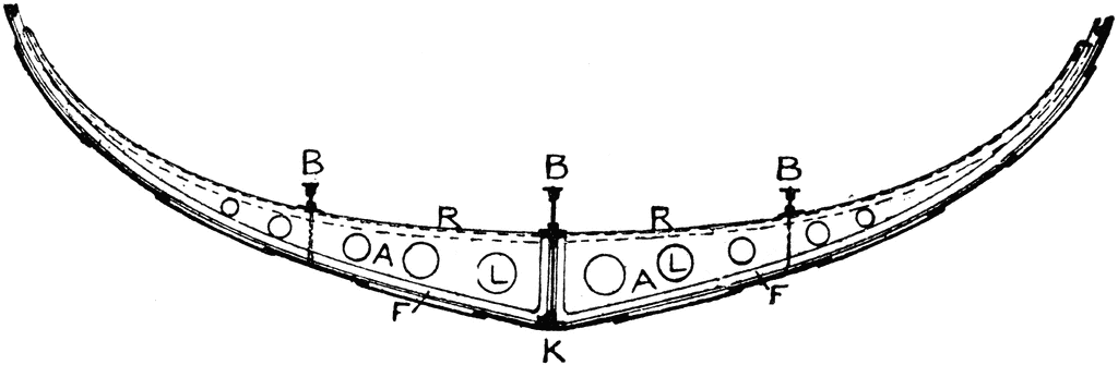
As the name suggests sticks were used to make these charts. Along with the sticks midribs of coconut fronds were tied in an open framework in such a manner that ocean swells and the islands were represented. The sea shells or the joints where two sticks meet represented the island and the threads represented the ocean surface. The charts were highly individualistic. Only the person who made it could read it and use it.

Categories of Stick Charts for Navigation:
The stick charts fall into three main categories:
Mattang Charts:
The Mattang Charts were also known as Wappepe Charts. These were primarily an instructional tool. These were used for educating about the ocean swells.
Meddo Charts:
The Meddo Charts were used for indicating the location of the actual islands and the swells around these islands. These were also used to indicate the intersection of swells and the approximate distance from a canoe at which an island sould be easily detected. These charts did not cover the entire region but covered only certain sections of main island chains.
Rebbelib Charts:
The Rebbelib charts were on the same lines as the Meddo charts, with the difference that these were more comprehensive and included most of the island chains.
Ocean Swells:
Four main ocean swells were recognized by the Marshallese. The swells were-
Rilib Swell: It is the strongest swell and considered as the backbone. Generated as a result of the north east trade winds, it was observed through out the year.
Kaelib Swell: This particular swell was weaker than the Rilib Swell. Though it was also present through out the year, it required a skill to be recognized
Bungdockerik Swell: The swell is as a strong swell, often as strong as the rilib swell. It arises in the south west and is present through out the year.
Bungdockeing Swell: This is the weakest swell and is mainly observed in the northern islands. Hence we have learnt that stick charts for navigation were one of the earliest forms of cartography used by man. These charts were used at a time when the sextant or the compass had not been invented. It was a paperless technique to map the islands and the swells around these islands.


Hope you have a better idea of stick navigation charts after reading this article.
Stick Charts For Navigation,